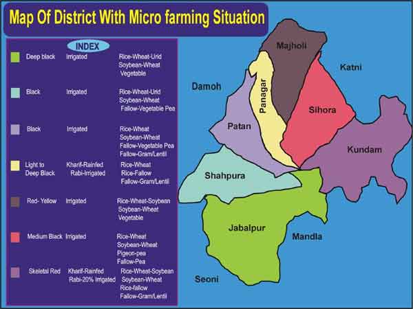
Jabalur District
KVK, Jabalpur is a grass root level institution centrally located in the district of Madhya Pradesh, which comes under Kymore Plateau and Satpura Hills Agro Climatic Zone (Zone-VII ).The district has 1393 villages and spread in 5,19,757 ha geographical area. The climate of the district is congenial for successful cultivation for oilseed, pulses, cereals and horticultural crops, with the annual rain fall of 1358 mm. The maximum temperature is in May (40-430C) and minimum temperature is in January (8-100C). Crops like Paddy, Pigeon pea, Soybean, Maize, Sesame in kharif and Wheat, Gram, Pea and Mustard in rabi are grown predominantly in the district. The total area under irrigation is 28% out of which only 18% is double cropped in this district.

District profile
No .of Blocks |
07 |
No. of Panchayats |
528 |
No. of Villages |
1393 |
Villages in each Block
Block |
No. of villages |
Sihora |
150 |
Kundam |
192 |
Jabalpur |
196 |
Panaga |
200 |
Majholi |
208 |
Shahpura |
220 |
Patan |
227 |
Land Use Pattern of Jabalpur District
Total Geographical Area |
5,19,757 ha |
Forest Area |
77,654 ha |
Fallow Land |
57,920 ha |
Total cultivated Area |
3,67279 ha |
Other degraded land |
16,904 ha |
Cropping intensity |
136.45 |
Major soil type |
Medium & Black soils |
Nutrient consumption (NPK) |
39:21:2 |
Distribution of population in Jabalpur District
Total Population |
2151203 |
No. of Farmers |
923863 |
Farm Families |
399440 |
Large Farmers |
171048 |
Medium Farmers |
52582 |
Small Farmers |
26079 |
Landless Farmers |
149731 |
Productivity of important Kharif and Rabi crops of the district
Crop |
Area (ha) |
Productivity (Kg/ha) |
Paddy |
64184 |
941 |
Soybean |
2240 |
891 |
Arhar |
6798 |
1257 |
Maize |
4290 |
1666 |
Wheat |
87879 |
2243 |
Gram |
66450 |
1141 |
Mustard |
4147 |
1027 |
Soil Type and its Characteristics
Soil Type |
Area covered |
Characteristics |
Heavy Soil |
(45%) Area covering blocks Jabalpur, Patan, Shahpura, Panagar |
High in Organic carbon& water retention, deficient in Zinc, |
Medium Black Soil |
(25%) Area covering blocks Majholi, Sihora, Shahpura |
Medium in O.C. & moderate in water retention, deficiency in Zinc, pH -6.5-8.1 |
Light soil |
(30%) Area covering blocks Kundam, some parts of Jabalpur, Sihora |
Gravel and sandy soil, low in O.C., pH-6.0-7.0 |
Agricultural scenario
In the district, 80 per cent is the agrarian population dependent on farming. Most of the farming situation is rainfed (64 %). The major crops are paddy, soybean, urd, wheat, gram, pea, etc. The existing position of crops/farming systems is given below:
Farming situations/systems |
Area (%) |
Extent |
Cultivated area mainly rainfed |
64 |
Large |
Cropping intensity (136%) |
35 |
low |
Cropping pattern (Coarse cereals in Kharif ) |
34 |
- |
Tribal, marginal and small farmers’ population |
27 |
- |
Unproductive animals (fodder shortage) |
60 |
High |
Area affected due vagaries of nature |
45 |
High |
Soil fertility status |
35 |
Poor |
Seed replacement rate |
40 |
Low |
Fertilizer and pesticides consumption |
60 |
Low |
Pest and diseases incidence |
75 |
High |
Use of fallow or degraded land |
20 |
Low |
Large run off and soil erosion |
40 |
High |
Thrust areas identified based on Participatory Rural Appraisal of the district
- Enhancement of Seed Replacement rate
- Formation of Seed production groups/societies
- Replacement of low value crops through more productive high value crops
2. Integrated Nutrient Management
- Soil enrichment through recycling of farm waste and use of bioinoculants as biofertilizer alongwith organics
3. Soil & Water Management
- In situ water conservation and groundwater recharging through run off harvesting and mulches.
4. Integrated Pest and Disease Management
- Deep summer ploughing and tmely sowing with seed treatment and use of botanicals, bioagents and biopesticides
5. Integrated Farming Systems
- Genetic upgradation of livestock
- Feed and fodder management
- Health and Care of animals
6. Improvement in cropping intensity in rainfed areas